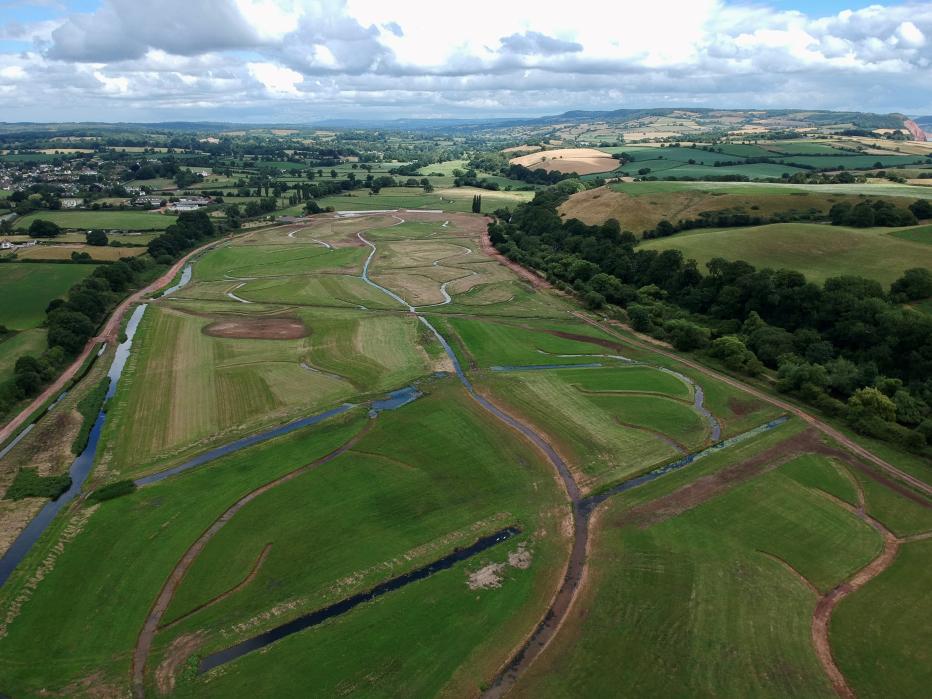
New creek network constructed in the upper parts of the site
What will the project achieve?
The project will restore the Otter estuary, reconnecting it with its floodplain and creating approximately 136 acres (ac) [55 hectares (ha)] of mudflat and saltmarsh, and providing a better place for people and wildlife. The project has multiple goals, including:
- Delivering more sustainable management in the face of climate change.
- Improving the natural functioning of the Otter estuary, and improving the quality of habitats and wildlife.
- Providing compensatory intertidal habitat.
- Safeguarding public access.
- Reducing the risk of contamination from the old municipal tip.
The project area comprises of a single landowner, Clinton Devon Estates, seeking to manage the lower Otter estuary as sustainably as possible in the face of a rapidly changing climate.
The Environment Agency is delivering increased resilience to climate change whilst delivering compensatory habitat to offset losses of intertidal habitat caused by sea level rise.
-
136
The scheme will create up to 136ac (55ha) of new intertidal habitat with an additional 7.4ac (3ha) of new grassland and woodland habitat.
-
6
The scheme will excavate more than 6km of new channels to allow flood waters to flood and drain throughout the site.
-
330000
To accommodate the new creek channel it will be necessary to remove approximately 330,000 imp ga (1,500m3) of former landfill material, which will be disposed of at an appropriate facility.
-
72831
Between 28,542 (29,000 tons) and 72,831 imperial tons (74,000 tons) of CO2 equivalent over the next 44 to 72 years.
-
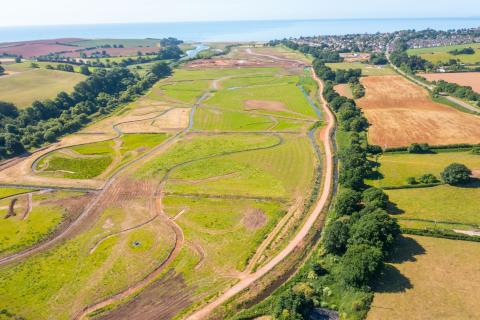
The Lower Otter Restoration Project site under construction. Credit KOR Communication/ East Devon Pebble bed Heaths / Clinton Devon Estates.
-
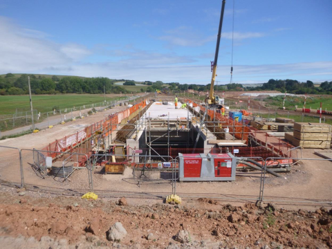
Construction of highway bridge at South Farm Road
-
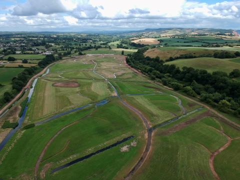
New creek network constructed in the upper parts of the site
The challenge
The Lower Otter valley has been heavily modified by human intervention. Since the creation of an embankment in the early 19th century, the River Otter has been disconnected from much of its original floodplain. The embankments, a road, a rubbish tip, a concrete aqueduct which canalizes a key tributary to the River Otter are difficult to maintain and restrict natural processes including the movement of water. This reduces habitat quality and diversity.
The effects of climate change mean that key infrastructure now located in the former estuary area is at increasing risk to extreme weather events and sea level rise. The Lower Otter Restoration Project seeks to manage these impacts and help the Lower Otter Valley adapt for the future, moving vulnerable infrastructure and making it resilient to flooding where this cannot happen.
“The project will have huge benefits, not only through the way we adapt to meet the challenge of climate change, but to the people and wildlife that share this area”
The Lower Otter Restoration Project
The implementation of the project will enable the Environment Agency to mitigate some of the effects of climate change by creating intertidal habitat (saltmarsh and mudflat) which is nationally important and is being lost due to the effects of rising sea levels. The project will also improve the natural functioning, ecological health and environmental status of the river, adapt to sea level rise, and reduce risk to wildlife and public infrastructure under future climate change scenarios. The sediments that will be deposited within the site will also function as a blue carbon store.
The breach was undertaken in September 2023, allowing tidal conditions to return to the former estuary flood plain for the first time in over 200 years.
Our activities included:
- Option assessment – options including full-scale restoration of the Otter estuary and river channel, through assisted natural recovery to floodplain restoration.
- Consultation – support to the Environment Agency, in consultation with statutory and non-statutory bodies, residents and the public.
- Environmental assessment and design – production of the Environmental Statement presenting the findings of a statutory Environmental Impact Assessment.
- Geotechnical and highway design – 1,649 feet (500 meters)-long road raised on an embankment up to 9.8ft (3m) high and passing over the municipal waste tip. Embankment settlement during construction was monitored using an observational approach.
- Habitat and landscape mitigation and enhancement design - including 7ac (2.9ha) of woodland and scrub planting, over 1.2 miles (2km) of hedgerow planting (over 22,000 plants in total) and 19ac (7.7ha) of grassland and meadow seeding.
- Structural and geotechnical design – 98ft (30m)-long, two-lane, three-span highway bridge, and 246 ft (75m)-span footbridge (substructure) over the breach to the estuary.
- Hydraulic modelling – use and development of model to support design and flood risk assessment.
- Creek system and breach design – to ensure that site floods and drains correctly and that a range of habitats for vegetation and other species are created.
- Consenting / legal agreements – support to the Environment Agency in gaining planning consent, land drainage consent, Marine Management Organization consent and highways legal agreements.
-
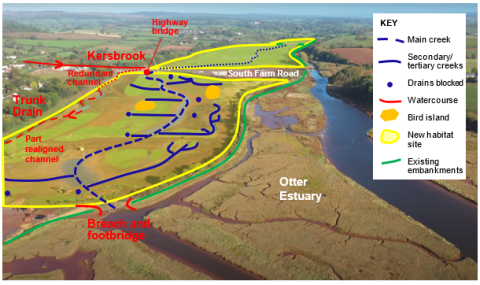
Southern part of the site
-
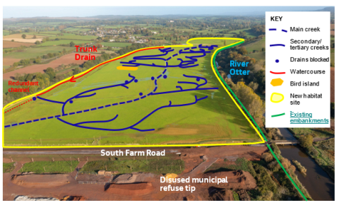
Central part of the site
-
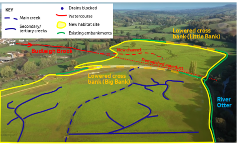
Northern part of site
“The Lower Otter Estuary is a special place – home to local people, businesses and wildlife and enjoyed by thousands of visitors each year. We are proud to have played a part in delivering this important project with the Environment Agency, to provide a sustainable approach for adapting to climate change, a sanctuary for wildlife and a valuable blue carbon store.”
Key team members
-

Toby Wilson, Project Manager
Successfully coordinated multidisciplinary teams to deliver a detailed design through close working relationships with key stakeholders. Toby has previously worked on other large-scale restoration schemes, including Steart Managed Realignment.
-

Simon Murray, Landscape Architect
Simon led the landscape design and landscape and visual impact assessment, working with the engineering and environmental team to minimise adverse impacts and maximise the opportunities to enhance and integrate the scheme within the highly sensitive AONB landscape.
-

Steve Bishop, Geotechnical Lead
Supported by his team, Steve oversaw and managed the multi-phase ground investigation campaign and the geotechnical design of two piled overbridges, a new highway embankment over soft/compressible ground and site-wide earthworks. He also provided on-site technical support during construction.
-

Lynne Bonsall, Planning Lead
Working alongside the engineering team and the Environmental Impact Assessment coordinator, Lynne has prepared the planning documents to be submitted in support of the applications for planning consent and marine consent. The scheme includes the provision of new footpaths and improvements to the access and recreational facilities throughout the area.
-
Simon Morrison, Design Manager
Responsible for managing the design teams to deliver a high-quality design. The process of delivery on time for construction has been challenging due to a tight programme, and refinements of construction methodology needed in response to site conditions.
-

Ben Robbins, Highways Lead
Alongside a wider team, delivering the design for the South Farm Road element of the scheme, encompassing realignment of 540m highway, improved access to 3.3km of foot path, raised circa 2.5km of footpath, 48-space car park and associated flow control structures.
-

James Tempest, Habitat Creation Specialist
Undertaking the detailed work on the creek design and analysis of reference sites, and also assisting in the assessment of impacts on the wider estuary.
-
Nigel Pontee, Coastal Realignment Lead
Providing technical direction of the design of the breach and creek systems within the project, the hydrodynamic modelling and the assessments of impacts on the wider estuary.
Award highlights
CIEEM Awards 2024
- Best Practice Award: Large-Scale Project Mitigation, Compensation and Enhancement
- Tony Bradshaw Best Practice Award




.jpg?h=c7c14dee&itok=FmPI2126)






_0.jpg?h=8a6d63f3&itok=5vsqFiQH)







.png?h=1314d3d4&itok=rFs9mG95)
